Featured Projects
This project is developing a partner-driven, science-based approach for identifying and prioritizing culvert road stream crossings in the area impacted by Hurricane Sandy for increasing resilience to future floods while improving aquatic connectivity for fish passage. The resulting information and tools will be used to inform and improve decision making by towns, states and other key decision makers.
Through a stakeholder-driven process, the project team developed a multi-criteria decision support tool to allow resource managers to visualize and manipulate information on aquatic habitats and threats to prioritize areas for conservation action.
This project developed a comprehensive terrestrial habitat map for the entire extent of the North Atlantic Landscape Conservation Cooperative (NALCC) region by extending the Northeast Terrestrial Habitat Map to Atlantic Canada and southern Quebec. The completed version was released on September 10, 2015.
The objective of this project was to develop tools to assist managers in protecting and restoring streams for brook trout and other aquatic resources in the face of threats such as climate change and development. Deliverables from this project included models of stream temperature, stream flow, and brook trout occurrence for headwaters of the Northeast, including projections of the potential effects of climate change. The investigators worked closely with decision-makers such as state water resource agencies to ensure the tools are useful.
Search Results
Sort by:
Alphabetical
Most recent
Oldest first
NALCC-funded
Completion Date
December 2013
This project integrated NOAA and NatureServe's Coastal and Marine Ecological Classification Standard (CMECS) and the Nature Conservancy and NatureServe's Northeast Regional Habitat Classification System (NRHCS) in order to extend the latter system to estuarine and marine environments from Maine to Virginia. State, academic, and non-profit partners collaborated to identify and cross-walk existing state marine classification systems. The project examined the scalability of this classification by conducting pilot mapping projects at three different scales relevant to planning and conservation efforts.
Completion Date
September 2016
Coastal change is a shared challenge along the Atlantic and Gulf Coasts of the United States, yet there are vast differences in the tools and information available in these regions. This project coordinated, synthesized, and delivered coastal resilience information, activities and lessons learned across the coastal portion of the Atlantic, Gulf and Caribbean Landscape Conservation Cooperative (LCC) network.
Completion Date
January 2017
This series of reports, databases, and data layers generated using Google Earth imagery provides an inventory of sandy beach and tidal inlet habitats from Maine to North Carolina, as well as modifications to sandy beaches and tidal inlets prior to, immediately after, and three years after Hurricane Sandy.
Completion Date
June 2013
NatureServe and Heritage Program collaborators have developed a Climate Change Vulnerability Index (CCVI) to provide a rapid, scientifically defensible assessment of species' vulnerability to climate change. The CCVI integrates information about exposure to altered climates and species-specific sensitivity factors known to be associated with vulnerability to climate change. This project applied the CCVI to 64 species selected in collaboration with state wildlife staff and other experts.
Completion Date
September 2013
This project completed a rapid update for wetland mapping in 162 coastal areas (1:24,000 topographic quadrangles in ME, MD, MA, NJ, NY, PA, and VA) that were last updated prior to 2000. The updates, which were incorporated into the National Wetland Inventory, have many applications in conservation analysis and coastal planning, including the Designing Sustainable Landscapes project (also funded by the North Atlantic LCC).
Completion Date
April 2014
One of the principal impacts of sea-level rise will be the loss of land in coastal areas through erosion and submergence of the coastal landscape. However, changes vary across space and time and are difficult to predict because landforms such as beaches, barriers, and marshes can respond to sea level rise in complicated, dynamic ways. This project developed decision support models to address critical management decisions at regional and local scales, considering both dynamic and simple inundation responses to sea-level rise.
Completion Date
September 2015
Through a stakeholder-driven process, the project team developed a multi-criteria decision support tool to allow resource managers to visualize and manipulate information on aquatic habitats and threats to prioritize areas for conservation action.
Under a cooperative agreement funded by the Hurricane Sandy Disaster Mitigation Fund, Designing Sustainable Coastal Landscapes in the Face of Sea-level Rise and Storms, will add needed coastally relevant information to the Designing Sustainable Landscapes project for the North Atlantic region.
Completion Date
August 2017
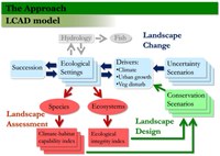
This project highlights the potential for collaboration and coordination among conservation practitioners and research scientists to plan for the future. A team of UMass scientists has developed a landscape change, assessment and design model to assess ecosystems and their capacity to sustain populations of wildlife in the northeastern U.S. in the face of urban growth, climate change, and other stressors. The project plays a major role in developing the science and data for two collaborative landscape planning and design efforts: 1) Connect the Connecticut, the pilot Landscape Conservation Design for the Connecticut River Watershed, and 2) Nature's Network, which expands and elaborates on the data to extend to throughout New England and the Mid-Atlantic. Using the best available science and information, participating partners are developing tools and strategies for conserving a connected network of lands and waters to sustain natural resources and communities within the watershed.
There is growing interest among conservation practitioners to have a method to assess tidally influenced crossings for their potential as barriers to aquatic organism passage. Protocols designed for freshwater streams will not adequately address the passage challenges of bi-directional flow and widely variable depth and velocity of tidally influenced systems. Diadromous and coastal fish must be able to overcome the enhanced water velocities associated with tidal restrictions to reach upstream spawning habitat. This project will build on the existing North Atlantic Aquatic Connectivity Collaborative's protocol, database and scoring procedures to extend the applicability of this region-wide program to road-stream crossings in tidally influenced settings.
Completion Date
May 2017
This project contributed to the development of a comprehensive aquatic habitat map for the entire extent of the North Atlantic Landscape Conservation Cooperative (NALCC) region by extending the Northeast Aquatic Habitat Map to Canada and southern Quebec.
Completion Date
September 2015
This project developed a comprehensive terrestrial habitat map for the entire extent of the North Atlantic Landscape Conservation Cooperative (NALCC) region by extending the Northeast Terrestrial Habitat Map to Atlantic Canada and southern Quebec. The completed version was released on September 10, 2015.
Completion Date
October 2016
The objective of this project was to develop tools to assist managers in protecting and restoring streams for brook trout and other aquatic resources in the face of threats such as climate change and development. Deliverables from this project included models of stream temperature, stream flow, and brook trout occurrence for headwaters of the Northeast, including projections of the potential effects of climate change. The investigators worked closely with decision-makers such as state water resource agencies to ensure the tools are useful.
Completion Date
September 2016
Dozens of species of landbirds, such as warblers, hummingbirds, and orioles, migrate through the Northeastern United States from their summer breeding grounds in the U.S. and Canada to their nonbreeding grounds as far south as South America. During the migration period, birds must find habitat where they can stop, rest and replenish their energy reserves. Conservation efforts are increasingly focused on identifying stopover sites that are important for sustaining migratory landbird populations. This project built upon prior work by the University of Delaware and USGS to use weather surveillance data and field surveys to map and predict important migratory bird stopover sites.
Completion Date
June 2017
Sea levels are expected to rise by one to six feet over the next century, and coastal sites vary markedly in their ability to accommodate such inundation. In response to this threat, scientists from The Nature Conservancy evaluated 10,736 sites in the Northeast and Mid-Atlantic for the size, configuration and adequacy of their migration space, and for the natural processes necessary to support the migration of coastal habitats in response to sea-level rise.
Completion Date
April 30, 2015
This study gathered existing stream temperature data, identified data gaps, deployed temperature monitoring to locations lacking data, and compared state-of-the-art stream temperature models across the Northeast domain.
Completion Date
November 2016
This project is a coordinated effort by Landscape Conservation Cooperative (LCC) partners to integrate existing data, models and tools with foundational data and assessments of both the impacts of Hurricane Sandy and the immediate response. The project will integrate new and existing data and build decision support tools to guide beach restoration, management and conservation actions. Project objectives are to sustain ecological function, habitat suitability for wildlife, and ecosystem services including flood abatement in the face of storm impacts and sea level rise.
Completion Date
November 2016
This project is designed to guide decisions about where to conduct tidal marsh restoration, conservation, and management to sustain coastal ecosystems and services, including the fish and wildlife that depend upon tidal marshes, taking into account rising sea levels and other stressors.
Designed by scientists to simplify consistent data collection and management, the iPlover smartphone application gives trained resource managers an easy-to-use platform where they can collect and share data about coastal habitat utilization across a diverse community of field technicians, scientists, and managers. With the click of a button, users can contribute biological and geomorphological data to regional models designed to forecast the habitat outlook for piping plover, and other species that depend upon sandy beach habitat.
Completion Date
September 2015
This project developed a series of maps depicting the distribution and probability of occurrence of marine birds in the northwestern Atlantic Ocean. The maps are intended to be used for informing decisions about siting offshore facilities; marine spatial planning; and other uses requiring maps of seabird distributions.
Completion Date
November 2016
This project is developing a partner-driven, science-based approach for identifying and prioritizing culvert road stream crossings in the area impacted by Hurricane Sandy for increasing resilience to future floods while improving aquatic connectivity for fish passage. The resulting information and tools will be used to inform and improve decision making by towns, states and other key decision makers.
Completion Date
December 2013
Coastal marshes serve a variety of important functions including flood control, spawning/rearing areas for marine life, and critical habitat for many bird species of conservation concern. The focus of this project was to facilitate local actions in Maine to accommodate the needs of coastal marshes to migrate landward in response to rising sea levels.
Completion Date
March 2014
The goal of the project was to help more efficiently achieve a resilient Appalachian forest landscape within the NALCC geography that would be built upon a broadly shared vision for a sustainable, connected mosaic of forest habitats and waters that are home to thriving intact ecosystems and human communities. This project was intended to identify and showcase efforts that, in the light of advances in climate adaptation, best contribute to effective landscape conservation actions in the region.
Completion Date
December 2013
The purpose of this demonstration project was to show how North Atlantic LCC science products can be used to inform conservation for a Northeast habitat and resilience "hotspot." The Trust for Public Land will integrate LCC and other science products into a clearinghouse and analysis tool for parcel-level conservation planning in the 2.7 million acre White Mountains to Moosehead Lake region of Maine and New Hampshire.
Completion Date
January 2015
Landscape permeability, also referred to as "habitat connectivity," is the ability of a land area to allow animals to move and disperse. This project evaluated and mapped landscape permeability across the eastern United States and southeastern Canada.
Completion Date
August 2014
This collaborative project provided biologists and managers along the Atlantic coast with tools to predict effects of accelerating sea-level rise on the distribution of piping plover breeding habitat, test those predictions, and feed results back into the modeling framework to improve predictive capabilities. Immediate model results will be used to inform a coast-wide assessment of threats from sea-level rise and related habitat conservation recommendations that can be implemented by land managers and inform recommendations to regulators. Case studies incorporating resilience of piping plover habitat into management plans for specific locations demonstrate potential applications.
Completion Date
March 31, 2017
This project created a prioritized list of rare plant species for conservation actions, with a comprehensive analysis of rarity, threats, trends, legal protection, inclusion in State Wildlife Action Plan revisions, conservation status, habitat, and climate change.
Completion Date
June 2016
Amphibians and reptiles are experiencing threats throughout North America due to habitat loss and other factors. To help conserve these species, this project will identify Priority Amphibian and Reptile Conservation Areas (PARCAs) that are most vital in sustaining amphibian and reptile populations, taking into account potential future climatic conditions.
Scientists developed models to examine the influence of landscape-scale variables like sea-level rise and beach-management strategies on bird nesting suitability.
Completion Date
September 2015
This project brings together the major partners involved in road-stream crossings to assess river and stream continuity and set priorities for restoring connectivity, and reducing flood damage to road crossings, within the North Atlantic region.
Completion Date
December 2015
This project updated the 2008 Northeastern Aquatic Habitat Classification (NAHCS) prepared by The Nature Conservancy and the Northeast Association of Fish and Wildlife Agencies (NEAFWA). The updates added a tidal component to the classification of streams and rivers and a mapped classification of lakes; the lake classification was revised in 2015.
Completion Date
January 31st, 2018
An urgent need exists to uniformly assess river corridors, including floodplains, and to prioritize areas for protection across the North Atlantic landscape. This project will develop a river corridor assessment method and conservation prioritization toolkit. The tools will be tested through three pilot projects across different topographies before being expanded to additional river corridors across the region.
A collaborative effort to assess risks and set response priorities for tidal-marsh dependent bird species from Virginia to maritime Canada.
Completion Date
November 2016
Combining marsh equilibrium modeling approach with a hydrodynamic modeling approach, this coupled model forecasts the evolution of marsh landscapes under different sea-level rise scenarios, with or without marsh restoration and storm surge factored in, to inform future management decisions with regard to system dynamics.
Completion Date
December 2014
This project, sponsored by the Northeast Climate Science Center, facilitated coordination among the scientific community to assess existing habitat classification and mapping products within the Northeastern and Midwest United States.
Completion Date
April 2015
This project developed a coordinated, multi-agency regional stream temperature framework and database for New England, the Mid-Atlantic, and the Great Lakes states. The project compiled metadata about existing stream temperature monitoring locations and networks; developed a web-based decision support mapper to display, integrate, and share that information; built a community of contacts with interest in this effort; and developed data portal capabilities that integrate stream temperature data from several sources.
Completion Date
September 2011
The project developed habitat capability models for representative wildlife species. It was part of a project led by the University of Massachusetts Amherst to enhance the capacity of partners to assess and design sustainable landscape conservation in the Northeast. These models (as subsequently expanded and enhanced by UMass) have been incorporated into two North Atlantic LCC-sponsored projects, "Connect the Connecticut" and "Nature's Network."
Completion Date
June 2016
Vernal pools are small, temporary bodies of water that can serve as critical habitat for frogs, salamanders, reptiles, invertebrates, and other species. This project compiled a comprehensive GIS dataset of known and potential vernal pool locations in the North Atlantic region, reviewing vernal pool mapping approaches, and demonstrating a remote sensing method to identify potential vernal pool sites.
Completion Date
June 2012
This project updated the Northeast Terrestrial Habitat Map by remapping the Virginia coastal plain and piedmont. (The previous version adopted the Southeast GAP map for these regions.) This resulted in a map that is fully consistent across the 13 state Northeast region (Maine to Virginia and West Virginia).
Completion Date
August 2014
This project completed three assessments of the vulnerability of terrestrial, aquatic, and coastal habitats (ecosystems) to climate change, including sea level rise. One assessment evaluated 13 terrestrial and wetland habitat types, the second evaluated cold water stream habitats, and the third evaluated coastal habitats. A database of coastal climate change projects and tools was also developed.
|
